Prior to 1800, executions took place in public on Lancaster Moor. Locals have long
speculated where exactly those executions took place.
Although the appropriately named Golgotha and the highest point of Williamson Park seemworthwhillocations for consideration, maps such as Yates’ 1786 both depict and place the
gallows within the triangle of land formed by Quernmore and Wyresdale Road, almost
opposite Highfield with the quarries (now Williamson Park) above the site.
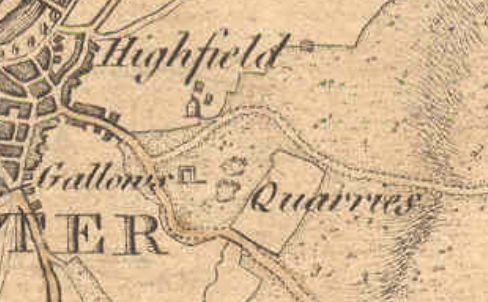
This then places the gallows on the land now owned by Lancaster Royal Grammar School
as their upper site but can we narrow the location further?
A key piece of evidence comes from the writings of local historian ‘Cross Fleury’ in his 1891
work ‘Time Honoured Lancaster’. In it, he talks about the tragic execution of poisoner Mary
Hilton who was strangled and burned (supposedly still alive) for murdering her husband in
A memoir within the book, recorded in 1825, states that Mary’s execution “took place
opposite the second window of the north of the workhouse”. This is problematic though;
Lancaster’s workhouse was not yet built on Lancaster Moor (building began 1787/88).
However at the time the memoir was recorded, the workhouse had been built but was still in
its small, earliest central block format (see Binns’ 1821 map).
“the mayor, &c., do give and grant liberty to erect a proper and
convenient poor-house on a piece of common ground on Lancaster
Moor, betwixt the two highways there, near to the stone quarries…”
Lancaster Corporation announcement. 1787
If we know then, that for a period of 12 years after, both the workhouse and executions were
in operation on the same location concurrently, this almost certainly meant that the paupers
of Lancaster Workhouse (particularly the male inmates whose dormitory windows faced the
place of execution had the misfortune of observing the 30 or so hangings that took place
during this time.
The choice of this land for building the workhouse on is perhaps not a surprise, it was after
all corporation-owned common land on the edge of town. The land was described as
“healthfully and pleasantly situate on the side of Lancaster Moor” and its size allowed for
future expansion of the workhouse site- a consideration due to the increasing town
population and the trend for moving prisoners, paupers and lunatics (sic) to less publicly
visible sites on the edges away from towns. Conversely, executions would be more fittingly
held at Lancaster Castle; the place of conviction and incarceration rather than the spectacle
and effort of taking everyone up onto the moors and trampling through the new workhouse
site. Furthermore, whilst the powers that be were not necessarily always kind to the poor,
there was some degree of sympathy and holding executions in full view of the deserving
poor would not have been considered appropriate.
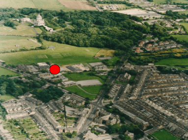
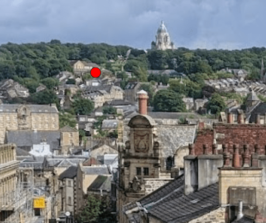
Early site plans of the workhouse from the 1820s and 1840s overlain over modern maps of
the Lancaster Royal Grammar School site now allow us to pinpoint a much smaller area
where death sentences were carried out. By overlaying the 1840s town plan of the
workhouse over a satellite map of LRGS we can project a line outwards from the ‘second
window from the north’ as recorded by Fleury (obscured by this stage by 1840s workhouse
expansions). Somewhere along this line is our mark. It is notable that this line follows the
historic boundary line between the moor and the town lands.
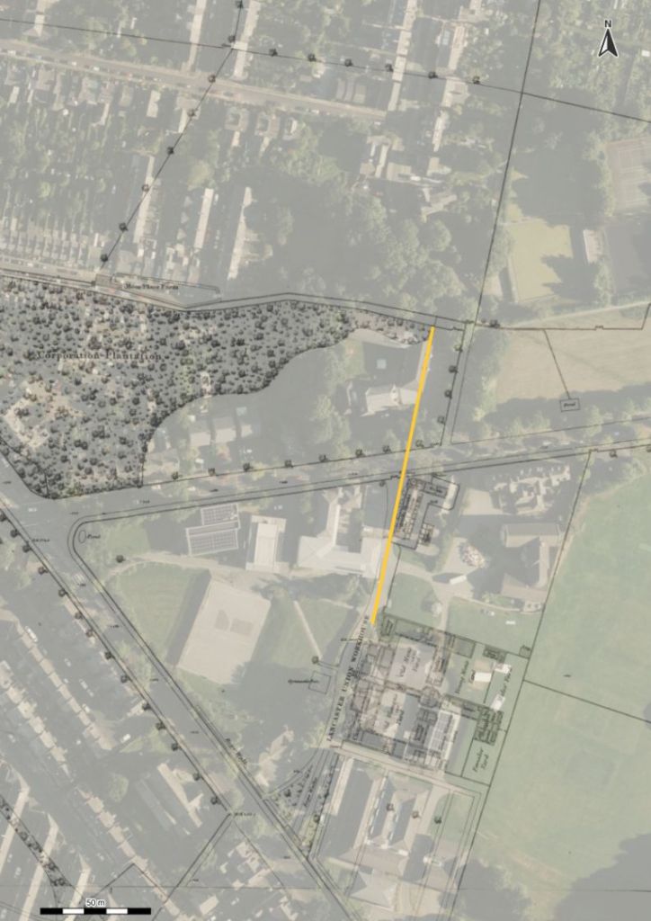
orientated towards second window from the north as recorded in Fleury
Before making a firm assumption though, based on memoirs and secondary evidence we
should question if the site of execution was fixed; could there have been a number of
different sites around this area? This is a perfectly legitimate argument and is certainly still a
possibility when we go even further back in time. There exists a contemporary map, not wellknown, which confirms that the execution site was still the same 100 years earlier. A map,
attributed to Richard Kuerden from 1685 gives a highly detailed and accurately surveyed
view of the town and beyond as he took measurements walking from the top of Clougha all
the way into Market Square in miles, furlongs and poles; passing by the gallows and marking
their location on the moor.
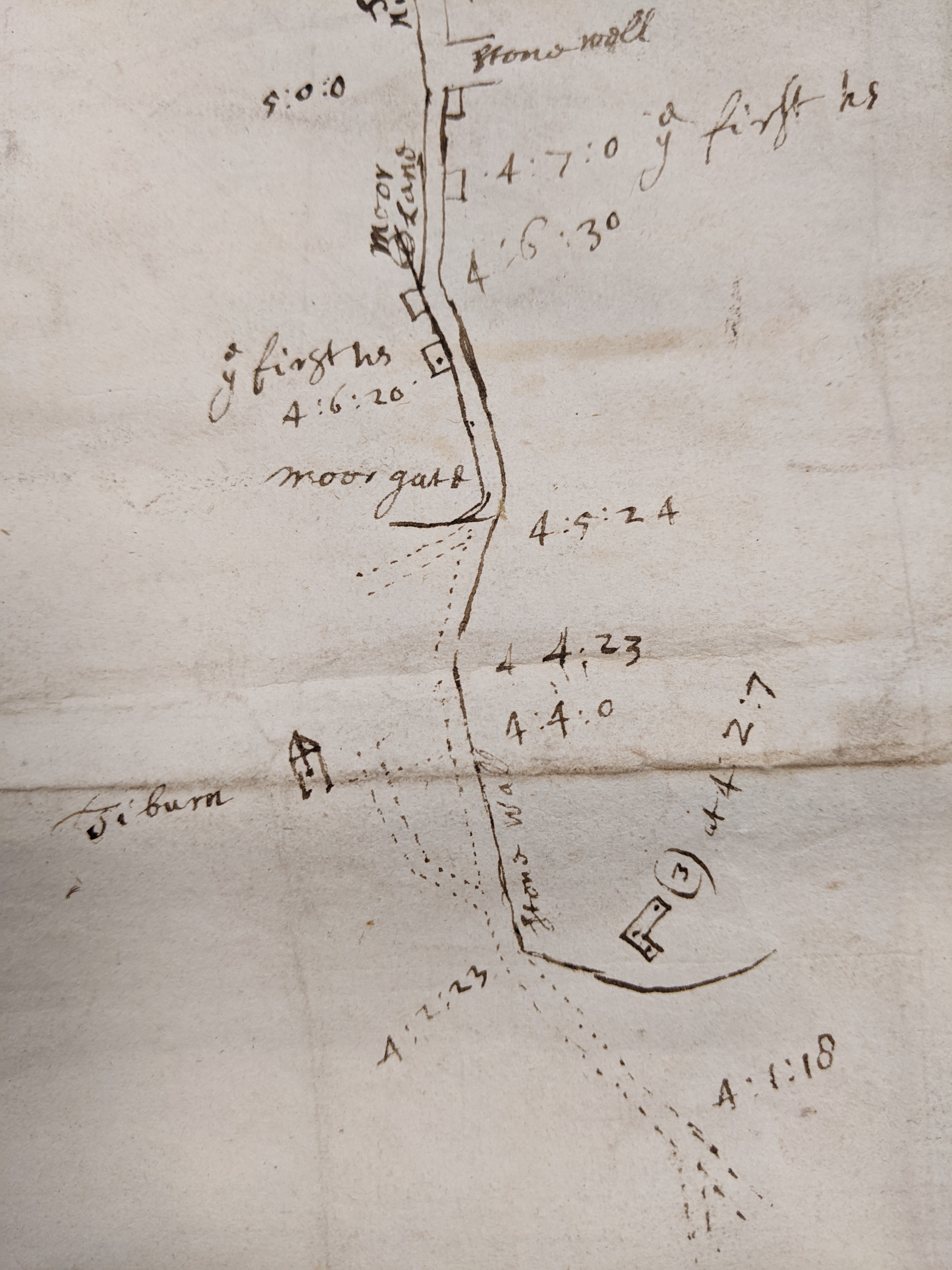
DDX 194/26. Lancashire Archives.
It is admittedly tricky to align this map as no other detailed contemporary maps exist of this
area at this time, but using the back wall of the Highfield estate as a fixed point (G), along
with Moorgate (C ) which was the literal gate onto the moors as marked on Binns’ 1821 map
being almost at today’s junction with Ullswater Road and the historic points of the old town
boundary (E) and the dip in Park Road where Moor Place Farm was (D), we can overlay
again on a modern map. Following the route as someone on foot (rather than as the crow
flies) and conversion of the furlongs and poles into metric measures of distance corroborates
these as the correct points. This of course reveals a slightly different route to the moor than
today. After passing by ‘ye first houses’, roughly where the canal and Moor Lane intersect,
you would climb uphill, as now, passing through the Moorgate. Though the road to the east
(Wyresdale Road) existed, Quernmore Road did not in the 1600s and even 100 years later
would still only be a minor lane), instead, you climbed a track, along the modern line of Park
Road, which still has a historic right of way at the top, crossing the town boundary (just
before the modern line of Derwent Road) and coming to the edge of the Highfield estate
which was bordered by a stone wall. The route cut across today’s Highfield recreational field
(previously the Workhouse Green but then just moorland). Finally, a further small track bent
back to the place labelled on Kuerden’s map as ‘Tiburn’. Tiburn had become synonymous
with gallows due to the well known London gallows of that name.
Kuerden himself described this area in his notes as thus- “and going through Scotford
(Scotforth)Town[…] half a mile further you come to the Moor leaving on the right above the
gallows an ancient seat call’d the Highfield. Here is a fair prospect of the town and castle,
entering into a little lane, leading into the town straight toward the castle…” (Earwaker. 1876)
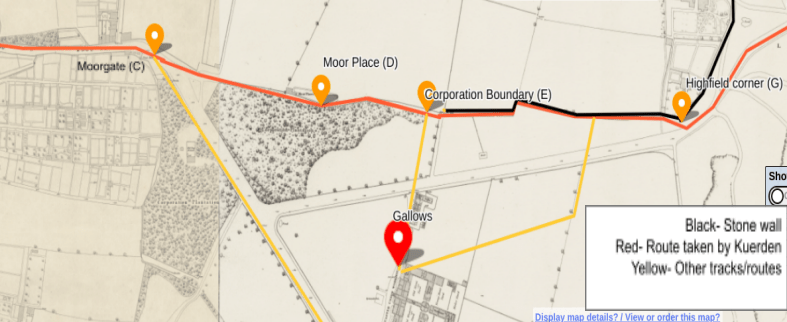
map. NLS maps/ OS 1840s town plan
We can also check against Kenneth Docton’s 1958 recreation of the Kuerden maps. In it he
shows from his lightly shaded box on the extreme right of the map ‘Tiburn 574 yards’ pointing up
Moor Lane. As the crow flies there are indeed 574 yards (525m) from the first houses to the
gallows site.
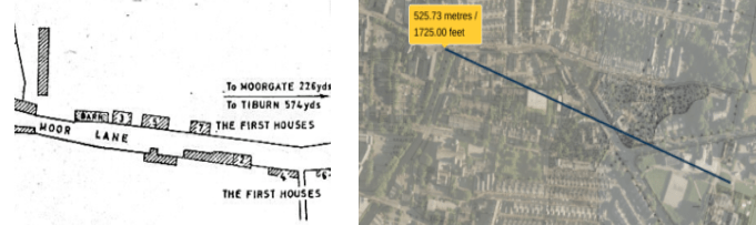
NLS maps with distance from the sites of the first houses to the gallows
Kuerden did not take a measurement from point (E) to the gallows and unfortunately his scale, drawing by hand, varies between 1mm on the map equating to 8-12m in real terms. However, using the defined edge of the workhouse building in 1788 as an end point, the evidence from Fleury and Yates and an average of 1mm on the map = 10m (14mm/140m from (E) to gallows) we are much closer to locating the spot.
To close, we can now pinpoint with some accuracy the location of the Lancaster gallows within LRGS grounds. The evidence places it in a grassed square near the electrical block (ironically a mortuary during the 19th century workhouse years) the modern school medical centre in Storey House and the Timberlake building. A newly built timber framed pavilion/shelter sits nearby the site today.
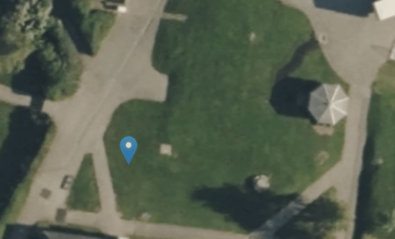
Aerial view during workhouse demolition 1960s. Lancaster City Museum
Notes on Kuerden’s Measurements
8 furlongs:1 mile
40 poles: 1 furlong
All measurements are from point to point on foot, distances were measured from Clougha Beacon to Lancaster Market Cross
Moorgate (C) to back Highfield wall (G)- 121 poles (608.5m).
Back Highfield wall (G) to town boundary (E)- 57 poles (287m).
Town Boundary (E) to Moor Place (D)- 23 poles (116m).
Moor Place (D) to Moorgate (C )- 41 poles (206m).
With grateful thanks to John Rogan at Lancashire Archives and Gregory Wright of Lancaster Walks Talks & Tours for their assistance.
